Please seek professional English editing services

Today I heard back from the journal we submitted our paper to a couple of months ago. The article was rejected, which is to be expected I suppose. At least that is what everyone tells me: expect rejections.

In all fairness I was also aware that peer-reviewers can be overly harsh and leave you feeling that your work is of no value whatsoever. Just take a look here if you don’t believe me.

However, what struck me about this rejection was a single sentence from the editor. I’ll provide it here in context:

In addition, the English needs improvements as the reviewers expressed difficulties of understanding or unclear statements throughout the manuscript. Please seek professional English editing services. You are welcome to use any editing service of your liking. If needed, professional English editing services are available at [redacted].

Ok, so my English is now so bad that I need “professional help”? Granted, I am not a native English speaker, but I still feel that I’m able to write rather understandable English. I know I should not be the judge of that myself, and according to the editor the “reviewers expressed difficulties of understanding or unclear statements throughout the manuscript”. Did they, now?

Here is what reviewer 1 has to say: “Finally, there are some grammar issues to fix.”

Reviewer 2 takes a page-by-page-line-by line approach, noting ~5 occurrences of spelling errors, and saying that the text in “unclear” in a couple of places.

Reviewer 3 has no comments regarding the language at all.

So, in light of this: One of three reviewers found several spelling errors and had trouble understanding some parts. This reviewer was also the most critical in other aspects, suggesting that the paper should be rewritten completely, as she/he does not agree with our main idea. Fair enough. But to extrapolate from that to say that the text is difficult to understand and that I need professional help? Chill the fuck down, mr. editor!

What I fail to understand is why feedback like this should warrant the statement: “Please seek professional English editing services”. To me this phrase sounds like: “you do not know how to write in English, do something about it!!”.

Well, maybe I’m just a bit angry and disappointed that the paper was rejected, but this just affirms my views on academic publishing. A complete lack of empathy and understanding and the idea that “since somebody once gave me harsh critique I need to be harsh as well”. Well, fuck that shit. By all means, point out my errors, encourage me to re-write and re-phrase myself, but don’t be such a fucking dick about it.

And, yeah, I don’t discard the idea that this “suggestion” is based on the fact that the publishing house probably makes some money on referring me to a “professional English editing service”.

Mendeley is dead, long live Zotero!

When I started out on my PhD two years ago I found Mendeley and thought it a perfect reference manager: Free to use, integrated with both MS Word and my browser and a generally easy-to-use GUI. What’s not to like?

Fast-forward two years. One of my papers was rejected and in the process of re-submitting it I needed to re-format the bibliography (more on that frustration in another post). Then Mendeley started acting up: “There was a problem setting up Word plugin communication: The address is protected”. Wtf? I re-installed the Word Plugin, I re-installed Mendeley itself, I tried some hints from this blog, I even watched a couple of YouTube videos. All to no avail. The Mendeley Word plugin did not work!

So I did what I usually do when life is mean to me: I took to Twitter. And complained. The Mendeley team was quick to answer, but their troubleshooting as nothing more than what I already had tried, plus encouraging me to “turn it off and then on again”. Nothing worked. A bit frustrated I replied:

Ok: how do I migrate my data away from Mendeley, and what is the best alternative to Mendeley?

The next day I had no reply and send a more official support request, and was met with this gem:

Dear Customer,

Thank you for submitting your question. This is to confirm that we have received your request and we aim to respond to you within 24 hours.

However, please note our current response time is 5 days.

Ok. Fuck this. I then remember hearing about Zotero, an Open Source reference manager. It seemed to offer both a Word-plugin and browser extension, as well as a method for importing my Mendeley data. Upon installation I chose “import from Mendeley” and found that it was not possible, due to encryption. I then found this site and found yet another reason to migrate away from Mendeley. Luckily my latest backup lacked only 20 items or so, so after 10 minutes of wrangling I had imported all of my data.

And I was impressed: Zotero understood that my Word doc was previously managed by Mendeley, and I did not have to change out all my references and rebuild the bibliography. So, in 30 minutes or so I had a working reference manager again, and I’ve moved from a closed platform incapable of providing adequate support to an open alternative that seems to work great!

So: if you are having trouble at all with Mendeley I would strongly suggest to migrate to Zotero!

Vsts: setting up tests and coverage to run on build for Javascript projects

I’m currently writing Javascript code, React and Redux to be more specific. After picking up the brilliant book “Human Redux” I’ve really started to enjoy this ecosystem.

But, remembering the brilliant Zombie TDD I also want to get back in the testing-game. This is quite easy when using create-react-app, as Jest is a great tool.

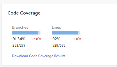
However, this is not the topic of this post. The topic here is how to get Microsoft VSTS (Visual Studio Team Services) to run your tests during the build phase, and report test results and coverage, and provide you with stuff like this:

2018-07-25 10_14_11-Window

coverage

You need to do stuff both to your project, and to your vsts build definition.

First off, your project:

You need the jest-junit package

npm install jest-junit -S

And, you need to edit your package.json file. First, add the top-level entry “jest”, with the following content

"jest": {
    "coverageReporters": [
      "cobertura",
      "html"
    ]
  },

and the top-level entry “jest-junit”, with the following content

"jest-junit": {
    "suiteName": "jest tests",
    "output": "test/junit.xml",
    "classNameTemplate": "{classname} - {title}",
    "titleTemplate": "{classname} - {title}",
    "ancestorSeparator": " > ",
    "usePathForSuiteName": "true"
},

Finally, you need to add the task “test:ci” to your script-block:

"test:ci": "react-scripts test --env=jsdom --testResultsProcessor=\"jest-junit\" --coverage",

So, what have we done here?

  1. We set the coverage reporters of Istanbul (which jest uses) write both the cobertura and html formats
  2. We set up jest-junit to produce junit-xml from our tests
  3. We create a test-task to be run on vsts that uses these two

You also want to add the resulting files to .gitignore

# testing
/coverage
/test

This should now work locally, test it by running

CI=true npm run test:ci
The coverage-folder should be created and the file test/junit.xml should be created.

So, everyting is good on the project side, time to move on to vsts.

Create a build, and add three tasks:

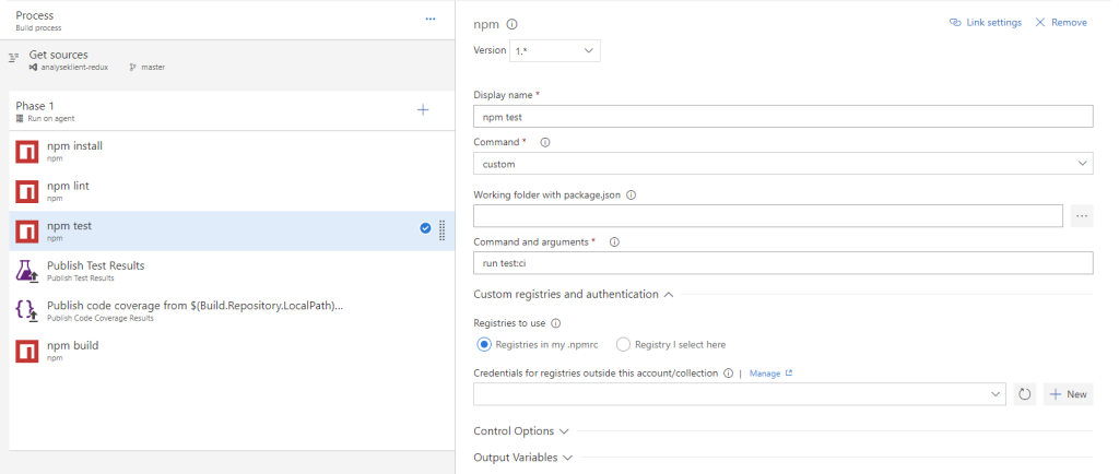
The first is an “npm” task, configure it like this
npm_test

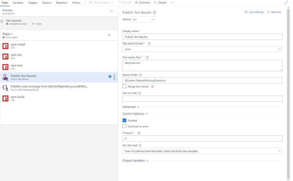
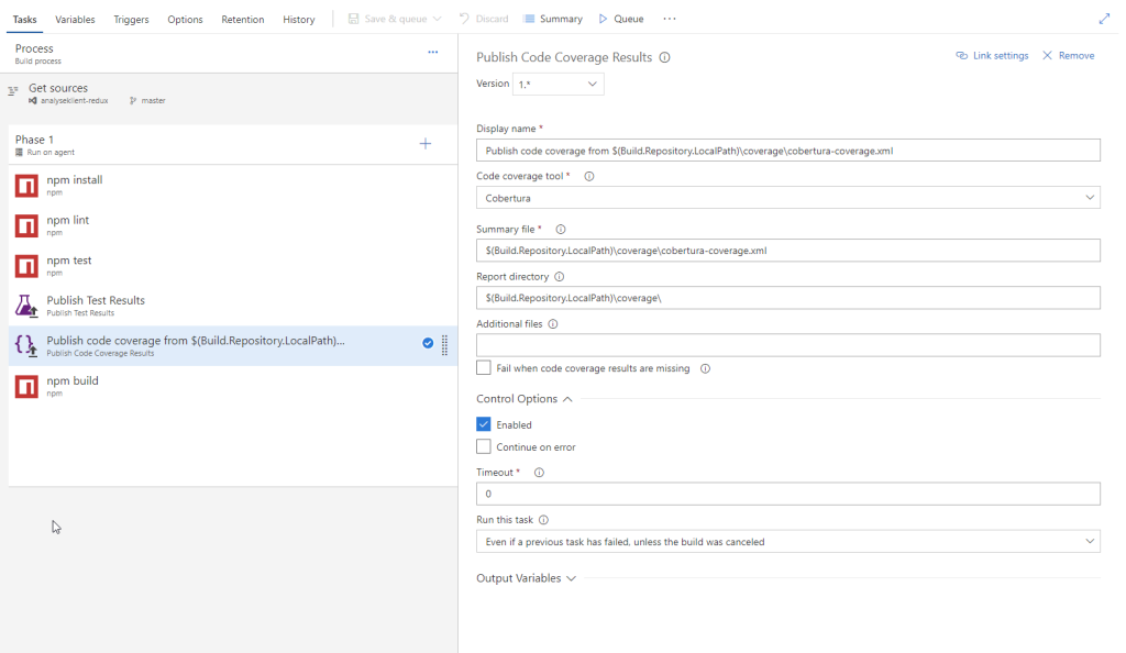
Then, you need to publish the results of the test and the coverage, so add a

“Publish Test Results” and a “Publish Code Coverage Results” task

npm_publish_test

npm_publish_coverage

Make sure you select “Even if a previous task has failed, unless the build was canceled” on the option “Run this task” under the tab “Control Options” for both publish tasks, as we want tests reports and coverage even if we have failing tests.

In addition you want to set the environment variable CI to true, in order for Jest to run all tests:

ci_true

With these things in place your build should now include test results and coverage reports!

The SOSI-format: The crazy, Norwegian, geospatial file format

Imagine trying to coordinate the exchange of geospatial data long before the birth of the Shapefile, before XML and JSON was thought of. Around the time when “microcomputers” was _really_ new, and mainframes was the norm. Before I was born.

Despite this (rather sorry) state of affairs, you realize that the “growing use of digital methods used in the production and use of geospatial data raises several coordiantion-issues” [my translation]. In addition, “there is an expressed wish from both software companies and users of geospatial data that new developments does not lead to a chaos of digital information that cannot be used without in-depth knowledge and large investments in software” [my translation].

Pretty forward-thinking if you ask me. Who was thinking about this in 1980? Turns out that two Norwegians, Stein W. Bie and Einar Stormark, did this in 1980, by writing this report.

This report is fantastic. It’s the first hint of a format that Norwegians working with geospatial data (and few others) still has to relate to today. The format, known as the “SOSI-Format” (not to be confused with the SOSI Standard) is a plaintext format for representing points, lines, areas and a bunch of other shapes, in addition to attribute data.

My reaction when I first encountered this format some 8 years ago was “what the hell is this?”, and I started on a crusade to get rid of the format (“there surely are better formats”). But I was hit by a lot of resistance. Partly because I confused the format with the standard, partly because I was young and did not know my history, partly because the format is still in widespread use, and partly because the format is in many ways really cool!

So, I started reading up on the format a bit (and made a parser for it in JavaScript, sosi.js). One thing that struck me was that a lot of things I’ve seen popping up lately has been in the SOSI-format for ages. Shared borders (as in TopoJSON) Check! Local origins (to save space) Check! Complex geometries (like arcs etc) Check!

But, what is it like? It’s a file written in what’s referred to as “dot-notation” (take a look at this file and you’ll understand why). The format was inspired by the british/canadion format FILEMATCH and a french database-system called SIGMI (anyone?).

The format is, as stated, text (i.e. ASCII) based, with the reason was that this ensured that data could be stored and transferred on a wide range of media. At the time of writing the report, there existed FORTRAN-implementations (for both Nord-10/S and UNIVAC 1100) for reading and writing. Nowadays, there exists several closed-source readers and writes for the format (implemented by several Norwegian GIS vendors), in addition to several Open Source readers.

The format is slated for replacement by some GML-variation, but we are still waiting. There is also GDAL/OGR support for the format, courtesy of Statens Kartverk. However, this requires a lot of hoop-jumping and make-magic on Linux. In addition, the current implementation does not work with utf-8, which is a major drawback as most .SOS-files these days are in fact utf-8.

So, there we are. The official Norwegian format for exchange of geographic information in 2018 is a nearly 40 year old plain text format. And the crazy thing is that this Norwegian oddity is actually something other countries are envious about, as we actually have a common, open (!), standard for this purpose, not some de-facto reverse-engineered binary format.

And, why indeed, why should the age of a format be an issue, as long as it works?

The Open Geospatial Data Ecosystem

This summer my first peer-reviewed article, “The Open Geospatial Data Ecosystem”, was published in “Kart og plan”. Unfortunately, the journal is not that digital, and they decided to withhold the issue from the web for a year, “in order to protect the printed version”. What?!

However, I was provided a link to a pdf of my article, and told I could distribute it. I interpret this as an approval of me publishing the article on my blog, so that is exactly what I’ll do.

The full article can be downloaded here: http://docs.atlefren.net/ogde.pdf, and the abstract is provided here:

Open Governmental Data, Linked Open Data, Open Government, Volunteered Geographic Information, Participatory GIS, and Free and Open Source Software are all parts of The Open Geospatial Data Ecosystem. How do these data types shape what we define as Open Geospatial Data; Open Data of a geospatial nature? While all these areas are well described in the literature, there is a lack of a formal definition and exploration of the concept of Open Geospatial Data as a whole. A review of current research, case-studies, and real-world examples, such as OpenStreetMap, reveal some common features; governments are a large source of open data due to their historical role and as a result of political pressure on making data public, and the large role volunteers play both in collecting and managing open data and in developing open source tools. This article provides a common base for discussion. Open Geospatial data will be even more important as it matures and more governments and corporations release and use open data.